When is the best time to hike in the Pyrenees?
What weather can I expect in the Pyrenees?
When is the best time to come hiking in the Pyrenees is one of the questions our guests ask most often. Here you can read a weather summary in each our main bases in the Pyrenees.
Mountain weather is something unpredictable and the Pyrenees have numerous microclimates and we find the weather can be very different in the short distance between the Valle de Tena and Ordesa or even on the east and west side of the Valle de Tena. Here you can see different graphics with the temperatures and rainfall of the area.
Generally we get northerly winds in the Pyrenees – this is perfect for the Spanish side of the range as any rain falls on the French side and Panticosa, Sallent de Gallego, Ordesa and Biescas sit in the rain shadow and are usually dry and sunny. A settled week with gentle northerly winds is the perfect (and most common!) forecast.
During the July and August thunder storms can develop late in the afternoon or in the evening. These mainly occur when a southerly wind blows hot moist air up from Spain’s central plains. In summer keep a look out when the forecast is for hot weather combined with winds from the south.
As you can see in the following graphics the best months to come are from early June to mid-July when the temperatures are warmer and most snow has usually disapeared from the highest paths of our hikes. Late July and August are hot with cooler nights. September is similar to June.
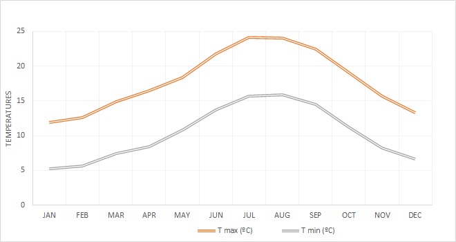
The following graphics are from climate-data.org which provide data collected between 1982 and 2012.
Biescas – Valle de Tena
860 m elevation. Biescas is base of Valle de Tena Explorer, Biescas Self Guided, Lakes & Valleys, and the first and last night of Village to Village, in all of them you’ll hike along the Tena Valley.


Sallent de Gallego
1350 m elevation. Sallent de Gallego is base of Sallent Self Guided and Peaks & Passes, and two nights of Village to Village.


Torla
1020 m elevation. Torla is the door of Ordesa National Park and is base of Discover Ordesa and Ordesa Self Guided.


When is the best time to hike in the Sierra de Guara?
What weather can I expect in the Sierra de Guara?
The weather in the pre-Pyrenees is perfect for early season hiking. When high mountains in the Pyrenees are still covered snow. The Sierra of the Guara National Park allows us enjoy hiking there.
On the other hand, its weather is too hot and dry to hike there in summer.
As you can see in the following graphics the best months to come are from April and May when the temperatures are warmer. Late September and October are perfect weather to go there too.
The following graphics are from climate-data.org which provide data collected between 1982 and 2012.
Alquézar
660 m elevation.The climate here is mild, and generally warm and temperate. Alquézar is base of our Villages of the Guara and Riglos&Alquézar.

When is the best time to hike in the Picos de Europa?
What weather can I expect in the Picos de Europa?
Summer is the best time to visit the Picos de Europa, it’s warm, not too hot, and there’s less chance of rain. Find showers.
There are two differents climates, in the North side with Cantabric sea influence there is an Atlantic one. Covadonga – Cabrales – area have a fairly damp and temperature maritime climate, completely clear days are not assured. Mists descend regulary. In the north slope the precipitations are more abundant because the mountainous front supposes a barrier for the fronts loaded with humidity that come from the Bay of Biscay. These fronts discharge in the Picos de Europa and in the area between these and the sea. The proximity to the sea and the same barrier effect is what favors a milder temperatures in the northern slope.
In the South area, the Cantabrian Picos – Fuente De area – there is an Atlantic – continental climate drier and hotter than the north side.
The following graphics are from climate-data.org which provide data collected between 1982 and 2012.
Cabrales – North area (Asturias)
150 m elevation. The climate here is mild, and generally warm and temperate. Arenas de Cabrales is where we start Picos de Europa guided holiday.

Potes – South area (Cantabria)
291 m elevation. Cosgaya, near Potes is where we spend the three last days in Picos de Europa guided holiday.


Village to Village
Hotel to hotel self guided hiking in the high Pyrenees
Arrive and depart on any day
1 June - 8 October 2025
Discover Ordesa
Dual level guided holiday
14 – 21 June 2025
12 – 19 July 2025
20 – 27 September 2025
Riglos y Alquézar
Twin centre guided holiday
10 – 17 May 2025
11 – 18 October 2025
Join Our Newsletter
Get updates when we publish new blog articles and information about the Pyrenees
The latest news from our blog

Grenache wine tasting
Our good friends George and Annie ran a wine tasting - or a cata as they are called in Spanish - in their village hall last week. They run wine tastings quite regularly, Annie puts on a great buffet and it's always a fun evening. George has lived in Spain for over 35...

Ski touring afternoon to Col des Moines
Last week we had a beautiful afternoon of ski touring with my American friend Nick. After a period of bad weather and snow, some sun shining days always come in our mountains!! Starting from Astún ski resort in Aragon Valley, we chose to follow one classical summer...

Quebrantahuesos bike race 2016
Quebrantahuesos is a huge bike race in the Pyrenees that shares its name with our famous Lammergeier vulture which is called 'Quebrantahuesos' in Spanish or the 'bone-crusher'! It's a appropriate name for this beast of a race which is 200km, crosses three big cols and...
Contact Hike Pyrenees
Phone:
Spain: +34 974 495 401
Visit our Facebook page
Visit our Instagram page