2019 GR11 Snow conditions update (posted May 28th 2019)
We’re starting to get people asking about snow conditions on the GR11 route for the 2019 season so I thought I’d write a quick update.
The Pyrenees in general had less snow than normal this winter. However, temperatures in May have been fairly cool without that much rain. With the colder temperatures, the rain we have had in the villages has fallen as snow above around 2200 metres. Therefore we have a situation where below around 2200 metres there is much less snow than normal – espceially on south facing slopes – but above this there is still significant snow and I would say conditions are more or less normal this season higher up. North facing slopes in particularl still have plenty of snow and crampons and ice axe are definitely needed on the higher sections.
Below is the webcam (taken today 28th May) from Refugio Respomuso towards Collado de Tebbarai (at 2782m one of the higher passes on the route – this is the northern side). I’ve drawn on the approx. route of the GR11. As you can see there is still substantial snowfields and I personally wouldn’t be crossing this without crampons.
Everyone have a great time on the GR11 – stay safe and make sure you are properly equipped for conditions. In times when you can’t go out and hike, try and play online slots games indoor. It is a great way to calm your mind when you want to get out.
Enjoy your hiking and the Pyrenees and let us know how you get on!
—————————————————————————————————–
The GR paths are a network of extensive paths that criss-cross Europe, mostly in France, Belgium, the Netherlands and Spain. In Spain, GR stands for ‘Gran Recorrido‘ and here in the Spanish Pyrenees, we have a number of these GR paths linking key settlements, passes and valleys, but perhaps the most challenging and impressive of these GR routes and the one that many of our hikes are based around is the GR11. The GR11 stretches the entire length of the Spanish Pyrenees, from Hondarribia, on the Atlantic coast to Cap de Creus, on the Mediterranean coast, and covers a total of 840km, which is divided into 46 day long sections, most of which start/finish where accommodation is available, either a campsite, town, refuge or hostel.
How long will take?
This does depend, to an extent, on your fitness, need for rest days and whether you wish to take some of the spectacular peaks along the way, but 45-60 days is the norm, however, it has been completed in a little as 24 days.
What to expect
The GR11 passes through the mountains of Navarra, Aragon and Catalonia, the latter two regions comprising of steeper and higher mountains, not to mention a hotter climate than Navarra. There are a number of high passes, above 2500m, in the central section and as much as 1600m of ascent / descent in a single day. The GR 11, is a much more recent path than the GR 10, which lies on the French side of the Pyrenees, and offers more wilderness, passes through less villages and probably has better weather!

Fuen Blanca is situted towards the head of the Anisclo Canyon and is one of the most remote spots along the GR11.
The GR11 is generally well marked throughout with red and white stripes, however, it would be foolish to head out without an understanding of mountain navigation, along with a map and compass. The terrain underfoot varies hugely, from straight forward 4×4 tracks, through to exposed and narrow rocky paths in high mountainous terrain, where a slip would be very serious.
When to go
The main walking season in the Spanish Pyrenees is between late May and the beginning of October, however this is not a hard and fast rule, as there can be snowfall well into June, and again in late September, which can cover many of the red and white painted markers. On the other hand, there may be some perfect windows of opportunity in the autumn, particularly as the temperatures will be cooler.
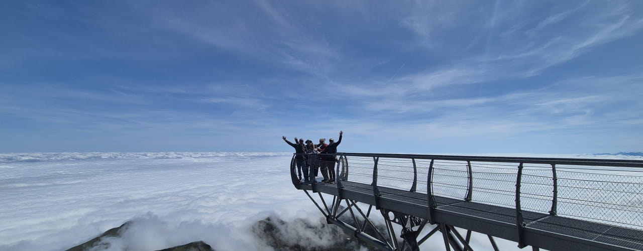
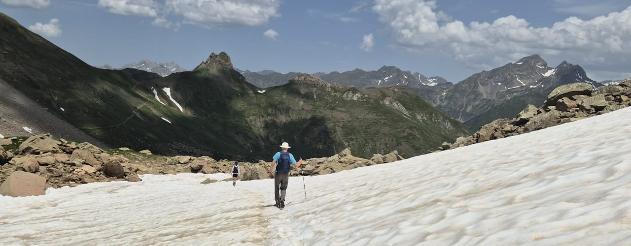
There will be unavoidable snow patches throughout June and probably well into July, and these should not be underestimated. Those looking to hike the higher sections of the GR11 during this period should carry both an ice axe and crampons, and have experience of using these. The presence of snow can turn a benign scree slope into a steep icy slope, which without the use of an ice axe and crampons could be potentially very serious should a slip occur. An example of is on the slopes leading up to the Cuello Tebarrai (2782m) from Refugio de Respomuso, which can hold snow until early August. Following a winter and spring of heavy snowfall, avalanche hazards can exist into June, particularly on hot, sunny days. Hut guardians can often be a great source of information regarding the conditions of the GR11 in the vicinity of their hut.
The Hike Pyrenees blog often has up-to-date photos and information regarding conditions in the Aragonese Pyrenees.
Wardened Huts or ‘Refugios’
The wardened ‘Refugios’ along the GR11 will play an integral part of the journey, and will no doubt be a welcome site after a long day of hiking. These should be booked in advance, either on-line or by telephone, and notified as soon as possible if you plan to cancel your booking also there are other activities like playing games or gambling in sites like w88 online. The facilities available do vary from hut to hut, but do remember that these are often located high in the mountains, where supplies are brought in either via helicopter or by mule. Some have showers and all will have a Plastic portable toilet in the location. They will all offer meals (including packed lunches) and often run a restaurant/bar service during the day. Prices are very similar from hut to hut and are as follows:
Overnight: 17 euros
Dinner: 17 euros
Breakfast: 6 euros
There is a certain etiquette for using mountain huts, and whilst they vary slightly from hut to hut, overall the following rules will help:
1) Check-in on arrival, where you will be allocated a bed within a specific dormitory. Let the warden know what time you’ll be up in the morning.
2) Boots are not permitted inside the hut, instead change into hut slippers or your own sandals.
3) Rucksacks are often not permitted inside the dormitories. Leave these in the designated areas (sometimes lockers) and only take what you need for the night to the dormitory.
4) Use a sleeping bag liner when sleeping, and ear plugs are a good idea!
5) Lights will all be turned off at about 10pm, make sure you have a head torch to hand.
6) In the morning, leave the dorm quietly, trying not to disturb others.
7) Take all your rubbish with you, otherwise someone else will have to.
It is worth noting that if you plan on spending many nights in mountain huts, to consider joining one of the large mountaineering organisations which provide reciprocal rights I.e. discounts of up to 50%. The Austrian Alpine Club (UK) is one such organisation.
- Refugio Respomuso
- A well earned beer
- Refugio Angel-Orus
- Refugio Viados
- Refugio Estos
- Refugio Bachimana
- Refugio Goriz
- Hut life inside
- Hut life outside
Variations and summits
There are an infinite number of variations possible, with all the official variations are listed here: http://www.euro-senders.com/web_eng/grspain/gr_011.htm and described in the guidebook The Gr11 Trail – La Senda: Through the Spanish Pyrenees (Cicerone Guides). These variations will generally be for one of three reasons: 1) the variation will be a more enjoyable and scenic, 2) the variation will be more logical, e.g. not loose unnecessary height to then reascend soon after, 3) the variation will be more convenient for using wardened huts.
Along with these variations, there are plenty of opportunities to take in some of the great Pyrenean summits, including: Pico de L’Infierno, Monte Perdido, Pico Posets, Perdiguero & Pico Aneto. Needless to say that extra time will need to be factored in, as most of these summits are side-trips (up and down the same route) from the GR11.
Kit
As with any trip of this nature, what you take depends on how you choose to play it, but the bottom line is to keep things as light as possible. The entire trip, from coast to coast, can be done, with careful planning, without carrying a tent or sleeping bag, however, this could well involve some big days of 30km+. There are plenty of resources in books and on-line that detail what you should take, but here are a few things to consider:
Rucksack: Needs to be big enough to fit all your gear in, but not so big that you end up filling it with unnecessary items. 55-65 litres should be ample. Contents should be kept in waterproof dry bags or a liner.
Sleeping bag: Only required, along with a lightweight sleeping mat, if you plan on camping along the way. A 3 season bag should suffice.
Sleeping bag liner: You must have a sleeping bag liner for the wardened huts (they provide blankets). This should ideally be a silk one, as they are very light and dry very quickly.
Boots: Must have good ankle support and a sturdy sole, as some of the walking will be on very rough or loose terrain. These will need to be stiff enough if you plan on using crampons.
Sun hat: Absolutely essential! The sun during the summer, at midday can be blisteringly hot, and without adequate protection, dehydration, sun burn and heat exhaustion are all much more likely.
Waterproofs: Again, absolutely essential. Don’t forget that just because you’re in Spain, during the summer, that you’re still in the mountains, where the weather can change very quickly, and whilst overall, it doesn’t rain much, when it does, it can be very heavy. That said, heavyweight mountaineering waterproofs are a bit of an overkill, go for something lightweight and breathable. This applies to waterproof trousers too.
Other essentials: map & compass, pure contact lenses, sunglasses, headtorch, at least 2 litres of water per day.
Books & Maps
Senda Pirenaica: GR11 Long Distance Path by JA Lopez Lafuente is one of the most comprehensive Spanish guidebooks to the GR11 and contains maps for each of the 47 stages.
Trekking in the Pyrenees (Trailblazer) by D Streatfeild-James covers both the GR10 and GR11 and includes all the practical information you need.
The Gr11 Trail – La Senda: Through the Spanish Pyrenees (Cicerone Guides) by B Johnson is another very comprehensive book that focuses solely on the GR11.
Useful websites
www.alberguesyrefugiosdearagon.com – for booking refugios in the Aragonese Pyrenees
www.lacentralderefugis.com – for booking refugios in Catalonia
www.yr.no – a very comprehensive weather website
www.mountain-forecast.com – another comprehensive weather website, locations are by mountain
Hey, great information! Thanks
I am planning a week in mid August. I’m flying in to Barcelona. Is there a section you would recommend for ~6 days of walking that is accessible with public transportation?
Thanks a lot!
Josh Golbert
You’d be able to reach the Valle de Canfranc or Valle de Tena in Sallent by public transport and then head east reaching Benasque which is also accessible by public transport. As we’ve said many times in answers to questions it’s not that easy to find areas that are accessible by frequent public transport services.
Hi Roger,
I’ve walked the sections from Parzan through the Posets-Maladeta park and for these areas I would say it makes no difference wether you walk east/west or the other way round. The same for Aiguestortes. The area around Andorra I don’t know very well so I’m not certain if there are sections that would be better one way or the other. I suspect that if you haven’t booked huts yet your choice of route may well be decided by hut availability now.
Phil
No – early August would be fine.
Dear Phil,
Many thanks for that information, and the warning about booking huts, I’ll do that asap. For that section Parzan – Arinsal , can I do that through one central booking or are they all individual bookings?
Once again, thanks,
Roger
Hej Guys
We are starting the GR11 mid July. Hoping to complete the walk or at least walking in that direction. Would you recommend carrying thermals, gloves etc for this period or is it overkill?
Regards
John
Hello,
I am planing to do some parts of the trail in August on my own. I wonder if it is totally mad to do it without someone else. Which sections are really dangerous (exposed steep slopes, snow)? Where is it demanding but okay? How is the Situation there, do people pester females hiking alone?
I have attempted to heed your warning about booking refugios in advance, but am unable to do so from the US. Any suggestions? I will be walking from Zuriza to Torla beginning September 13th. Tom
Hi Tom, Have you tried booking them at this site: http://www.alberguesyrefugiosdearagon.com/ ?
You should have no problem although maybe the site has problem accepting payments from US cards. At that time of year I don’t think you’ll have any problem with huts being full. Goriz in Ordesa is the busiest hut in the area but if you are ending in Torla then that won’t be a problem and you won’t be staying there. btw if you end in Torla give yourself one day to do a circular hike in the Ordesa Valley which is spectacular – look at either the Faja de Pelay or if you’ve a good head for heights the Faja de las Flores – both spectacular.
Have a great hike,
Phil
Any suggestions on lower elevation hikes? Well be in Catalonia in November without ski gear. We can do some snow hiking, but looking for ideas of where to go in the shoulder season. Thanks!
Hi,
I’am planning to do the first 10~14 days from the mediterranean side onwards to the Atlantic side ca. mid of March. I am quite experienced with hiking, alpine and long legs a day, but unsure up to with height might be safe at end of March when going alone and facing some snow, possibly ice. My assumption is that I might make it until Andorra, invite my family and then turn back to Barcelona after a wonderful weekend ,-) But I just started planning the day legs yet.
Any hints about if and how this is a good idea at this time? I should add that I will have full biwak stuff in my backpack, so I don’t need to care if refugios are open or not.
Thanks a lot,
Soeren
Hello, im trying to get as much informmation as I can about hiking the pyrenees in the winter. How is the snow, temperatures, storms, winds.. I have been doing some extreme adventures before, so I have some expirience. Can anyone share some informations? Thank you, Sandro
Hi.
Great that you have this website. Thanx. I want to walk the trail starting at the 5th of May. Now I was wondering if there is an app i van use for the trail with navigation, sleeping places etc?
Kind regards
Jorrit Dijkstra
Hi there,
Thanks for the useful information! I am going to do a smaller stretch of GR11 in early July: from Torla to Benasque. Do you know of the current weather conditions on this stretch – i.e. are there still stretches with snow?
Thanks a lot!
Best wishes,
Hanne
Hello , My family and I are hoping to do two nights worth of the GR11 during the summer (end July) . Is there a section near Pantacosa that you would recommend for us (two adults and kids 17 and 14). We are fit and happy to hike a good distance, but we are not experienced with crampons and ice axes. thanks very much for your help
Kim and Duncan
Hello. Planning to solo hike the GR11 starting at Burguete (via Pamplona) mid August 2019 until the end of September. Hoping to reach Cap de Creus. Bringing a tent for flexibility but will utilize various accommodations as needed/desired. Flying in and out of Barcelona from Canada.
Questions:
Do the refugios on the trail have a reciprocity agreement with the Alpine Club of Canada or the Slovenian Alpine Club or should I join the FEDME (Spain’s club)?
The location to purchase a screw on gas canister in Pamplona?
Is a water purifier needed?
Any info on transport to Burguete would be appreciated.
Thank you in advance.
Wai,
Pamplona has a Decathlon 3 km from the centre where you can definitely get a gas canister. There is at least one hiking shop nearer the centre too, but I can’t recall if it sells gas canisters.
I would take a water filter, although there are usually frequent drinkable water fountains you can’t rely on them.
From Barcelona airport you can get a bus to the centre, and from there to Pamplona (no changes) – you can book at goeuro.com. There is apparently also a bus from Pamplona to Burguete because of all the pilgrims on the Camino de Santiago, but you must buy the tickets at the bus station in Pamplona – http://www.autocaresartieda.com/?scc=roncesvalles
I will be on the trail at a similar time, although I am starting this year in Bielsa.
Thanks for giving all of the advice Gareth. Have a great trip this year on the GR11. Bielsa and the Pineta Canyon is a beautiful spot – although the ascent/or descent to/from Goriz is a bit of a killer!
Phil
Hei, we will go the gr11 in june. however, we found the following warning on the website http://www.travesiapirenaica.com:
WARNING: the section between Estanés lake and Candanchú has been discontinued. The new stretch of the route adds another day to the walk. From Estanés lake the route heads towards Lizara via valle de los Sarrios, Bernera bridge and Plana Mistresa. From Lizara you can take the variant GR11.1 or continue along the new stretch: Lizara-Collado del Bozo-Collado de Esper-Tuca Blanca-Tobazo-Candanchú.
Do you know if you can walk this route again now? Thanks a lot, Heidi
Hi Phil,
Planning to start hiking the GR11 21th of june, doing the full trail.
Could you give me an update about the snow conditions?
Kind regards
Anita
Hi Heidi,
They have re-routed the GR11 around Estanes and Candanchu. Personally, I think it was because the GR11 entered France for about a kilometre and the Spanish didn’t like that really! However, they tell me it’s because the new route is just better and prettier. To be fair the section that went into France was north facing with steep cliffs above you – a spot that is very avalanche prone and holds snow until late into the season. I snowshoed from Candanchu up to Ibon de Estanes this winter several times and although the route I took didn’t follow the Gr11 entirely (due to the avalanche-prone section mentioned before), I took a mixture of the GR11 and HRP and it was no problem at all. I have to say I haven’t had a chance to walk the new section yet (I’ll get round to it this summer). I know the area and the new route is pretty spectacular but as you say it adds a lot of distance, height gain and time. If you’re not worried about religiously sticking to the GR11 route then you’d have no problem hiking direct from Ibon de Estanes to Candanchu. I’ve not heard of any safety reason that this section was closed and if for any reason you couldn’t follow the old GR11 you definitely can hike from Ibon de Estanes to the parking of Sansanet and from there (perhaps with a bit of road) get to Candanchu. This summer I’ll hike the new route and take a GPS track and post it here but I probably won’t get a chance until August.
I hope that helps, have a great trip on the GR11 – it’s a fantastic route,
Phil
We are leaving the US with three of my six kids to do the GR11 this summer. I took five of my six to Santiago (actually Muxia and Finesterre) two years ago from Le Puy France to Santiago. The youngest was 9, all on foot and sleeping outside about 80 percent of the time. We connected the Le Puy route to the Norte via the GR10 from Saint Jean to Hendaye. We can’t wait to be back. We will be touring northern Europe for a month and then getting down to hike the Pyrenees. I don’t totally know what to expect, and I must admit my biggest fear is about obtaining food for us. IF you see us please say hi!!!!
Shefollowsshells.blogspot.com
Have a great trip on the GR11 and good luck. There are some sections where you’ll need to carry food for two or three days but you pass through a reasonable amount of villages on the way. Just remember that the shops will all be shut between about 2pm and 5pm!
If we see you hiking we’ll say hi and pass you a sandwich!
Have a great hike,
Phil
Hi Phil
We started on 22.05.19 with the GR 11. Now we are in Auritz. We also have crampons in our luggage. But we don’t want to take unnecessary risks. We will certainly walk to Sallent de Gallego on the GR 11. Afterwards we are not sure if it is possible to walk the route via the Collado de Tebarray? Do you know a good alternative? Many thanks in advance for your answer.
Anna and Sebastian
Hi there
My boyfriend and I are planning to hike the Pyrenees in September for 2 weeks. We will be leaving from Barcelona and would love to see Andorra, Garvanie and Ordessa (I’m sure there are plenty more to see ) but we are finding difficult to get information online about this route. Any advice ? Thanks
Hi Anna and Sebastian,
I’ve just posted an update above on current snow conditions along with a photo of current conditions on the Collado de Tebarrai. As you can see there’s still significant snow and I think you’d need crampons for this section. The alternative routes aren’t that great. From Sallent there are nice footpaths that head south to Panticosa, but from Panticosa there’s no footpath to Baños de Panticos (or Balneario) so it’s either about 8km walking along the road, hitch a lift or get a taxi. Also, the GR11 from Baños de Panticosa to Bujaruelo I think will still have snow (although probably a bit less).
Have a great hike on the GR11,
Phil
Hi All, I am heading to the GR11 with 3 friends next week. We are hoping to combine stage 13 and stage 14 in one. I.e. from Sallent de Gallego to Refugio Casa Piedra in Banos de Panticos. I appreciate that is a lot of walking but plan to drive north out of Sallent as far as the road goes which should cut 90 mins of walking out, leaving 8-9 hours of walking. Does that sound realistic or absolutely nuts?
Hi Phil,
Im starting my hike in GR11 on Saturday and I’m wondering the current snow situation. Do I need crampons for the section from Parzan to La Guingueta d’Anue? Also, my map hasn’t arrived yet by mail, so is there a shop in Barcelona/Bielsa/Parzan where I could buy a hiking map for GR11?
Many thanks in advance for your answer.
Hi there. We are starting the GR11 on August 14, 2019 going from the Atlantic side to the Mediterranean. Trying to find out which Alpine Club to sign up for in order to receive discounts at the refugios. Advice?
What is the current snow situation? Do you advice bringing crampons.
Would you know if the Decatlón store in Urin sells GR11 maps?
Hi Maya,
Apologies for the delay in replying – we’ve been very busy here with groups. There is very little snow in the Pyrenees this season. I don’t know the conditions for the whole route but in the area of the Valle de Tena and Ordesa you don’t need crampons – there is a very short section of snow around the Collado de Tebbarai but you should be able to cross it without a problem. We summited Monte Perdido last week without crampons. The countries that have reciprocal agreements are: Switzerland, Germany, Austria, France, Italy and Spain (obviously!). Also, Slovenia, Lichenstein and Holland have agreements although they don’t have huts themselves. Lots of people seem to join the Austrian Alpine Club as they say it’s quite economical and has a good insurance policy. I’m not certain about the maps in Decathlon but most branches of Decathlon have a good selection of maps and guidebooks. Personally, I’d buy in advance to make certain you have one! Hope that helps, Phil
Phil, I’m planning on walking the GR11 from mid August to early October in 2020 with 2 friends and have a few questions:
– Where would you recommend rest days (interesting town/ village, optional side trip/ peak climb or particularly beautiful spot). Looking at taking about 4
– how far ahead should you book refugios
Hi David,
Mid August is a good time to start the GR11 and you should get through all of the high sections before any early season snow.
For breaks, there are a few places that make sense. For rest and recuperation in a bit of comfort, I’d recommend a stop in Sallent de Gallego. It’s a lovely scenic village, nestled under the high mountains with nice restaurants and a couple of small supermarkets and outdoor shops to restock supplies. There are a few hikes you can do directly from the village (Punta del Pacino for an easy day with lovely views). Another village that is also worth a rest day is Benasque which is a great little mountain town with lots of outdoor shops – it’s kind of the Chamonix of the Pyrenees.
For an extra day in huts to do peaks there are a few of obvious ones. An extra day in Goriz (recently renovated so much more comfortable now!) would allow you to do Monte Perdido (3355m, third highest in the Pyrenees). An extra night in Angel Orus (if you take the GR11.2 variant) allows you to do Posets the second highest in the Pyrenees. And finally an extra night in either Refugio Llauset, Refugio Renclusa or in Benasque town would allow you to do Aneto the highest peak in the Pyrenees at 3404m from. If you’re in Benasque in high season there is a shuttle bus that runs to either Refugio Corones (an unmanned hut at a road head) to do Aneto from the south side or to La Besurta above Llanos de Hospital to do Aneto from the North side. Note: Aneto may well still need crampons even in August.
Al these are in the Aragonese Pyrenees as I know these much better but I’m sure there are a couple of good stops in Catalonia too – if anyone out there has any suggestions let us know.
For booking huts the popular ones such as Goriz and Renclusa get booked up early! Even as early as April it can be difficult to find availability in Goriz for August. If you’re outside August and not at a weekend it’s a bit easier to find availability.
I hope that helps. Have a great adventure on the GR11 and let us know how you get on.
Cheers,
Phil
HI Phil: I’m considering the GR11 this summer with my regular team of hiking friends ( 3 of us , we’ve done the TMB and AV1 over the last 2 summers ).
I’m having a hard time finding a clear map that has all of the accommodations available, and the recommended stages I’ve seen seem to be generally pretty long ( 20k plus).
I’m definitely ok with buying the book, but wondering if there are other resources out there? not finding them in my searches.
Thank you!
Hi Todd,
Information on the GR11 in English is sparse – hence we wrote this page to give a bit of advice. The maps will mark all of the huts on the route but won’t show accommodations in villages (although most maps show an H next to a village to indicate that there are hotels there). You’ll need to do a bit of internet research to find village accommodation but the likes of booking.com would help you with this. I’d recommend a few village stops to get a good rest – this hike is a LOT longer than the AV1 or the TMB.
It’s totally true that the official stages have some very long legs. It’s basically due to accommodations being along way apart. A tent gives you a lot more flexibility but obviously it’s a lot more weight to carry which will mean you can’t do such long stages!
A great book to start your research is the trailblazer guide ‘Trekking in the Pyrenees’ by Douglas Streatfield James. This has info about the GR10 (the French version), the GR11 and a bit about the Haute Route Pyrenees too. It has a bit of info on each village including some details of places to stay, if the village has shops to resupply, pharmacies, etc. It has route descriptions of each stage and small hand drawn maps so that you can see what you are letting yourself in for. As it’s not the ‘official’ guide it also suggest variants, side trips and contains a lot of general info on the Pyrenees.
It’s a good book to buy to start your research and then when you need the detailed maps you can buy the GR11 Prames guide which has all of the maps.
Hope that helps, have a great trip on the GR11 and let us know how you get on.
Phil
Hello just a quickie ..Starting approx. 20th june .Will I need crampons etc ..going from Cabo Higer to Refugio san Nicolas de Bujaruelo . Then leaving GR11 go over the Border to Gavarine . To come back in 2021 to continue . Hoping to complete in three visits . Maybe see you on the Trail ..Rob
Hi Rob,
A tricky one – you’re going to be right on the cusp of the period when you’d need crampons and it will depend a lot of conditions this summer. Up to Sallent de Gallego in the Valle de Tena you’ll almost definitely be fine without crampons. After Sallent though you have the Cuello de Tebbarrai which is 2782m and north-facing – you may need crampons here. On a warm day, you’d get through without, but on a cold day, the snow will be steep and icy and could be tricky. You’ll also be passing through the Col de Brazato on the way to Bujaruelo and then the Puerto de Bujaruelo as you go across to Gavarnie which are both over 2500 metres. Keep an eye on conditions (the Respomuso webcam is very useful to check conditions and points right at the Cuello de Tebbarrai). We post an updates on this page too. Right now there’s not much snow in the Pyrenees but there’s still plenty of winter left for a big snowfall, so it’s too early to take anything for granted yet.
Check back on this page late May and see what conditions are like. Have a great trip on the GR11,
Phil
stage 14 GR11 Do I need Microspikes or crampons .And maybe a ice axe …thanks
Of gr-11 I have done the part that goes from Puicerdà to Benasque with snowshoes and my backpack
. A great experience and highly recommended. Congratulations for the block
Will the huts/refugios along the GR11 be open by the beginning of September 2021?
If so, which is the best company I can use to book the required accommodations?
thanks a lot bro!
I am about to go or at least do a part of it. i wanna keep going and do the camino del norte afterwards.
one question, how did you manage to fitt stuff in a 30l????
I’m carrying like the most necessary with sleeping stuff, gas cooker, warm cloths, with water and food I’m having a full 75l backpack.
thanks again, blessings!
sea
Completed GR11 in 2007 solo, amazing experience and heading back in Aug 23, again solo for my 60th.
Thanks for the updates for my planning ????
I walked the Jakobsweg from Konstanz to L. Geneva then the GR5 to Nice in 2015. I’m excited to be planning another Euro Trek this year. Wondering what the snow situation is like this year, and what to expect in the first week of August? How does this trail compare to the GR5?